Geospatial
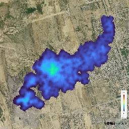
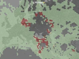
- Large meltwater accumulation revealed inside Greenland Ice Sheetphys.org Large meltwater accumulation revealed inside Greenland Ice Sheet
A new study published in Nature unveils a surprising discovery: a substantial amount of meltwater is temporarily stored within the Greenland Ice Sheet during summer months. For the first time, an international group of researchers was able to quantify meltwater with positioning data. The finding cha...
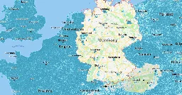
- [DE] Contribute network location data to get location everywhere without sattelites!tux.social Rhababerbarbar (@Rhababerbarbar@tux.social)
Wie geht einfache schnelle Standortbestimmung überall,, auch in Gebäuden und ohne Satteliten? Hier hilft #NLP (network location position), also Standortbestimmung ohne #GPS oder #AGPS Mithilfe von Datenbanken kann dein Handy dir so sagen, wo du bist, aufgrund von umliegenden Mobilfunktürmen, WLan...
Opensource geodata of celltowers, wifis and bluetooth beacons is crucial.
It allows apps like UnifiedNLP to give the OS the location data it needs, without relying on GPS Sattelites.
GPS can be tampered with, and A-GPS is not privacy friendly at all.
UnifiedNLP is only found included in microG, which is pretty insecure.
But GrapheneOS devs are working on a regular user app that serves network location data, using Apple, Apple (proxied) or a local BeaconDB database!
BeaconDB is a new service to replace MozillaLocationServices which has shut down unfortunately.
Apps like TowerCollector dont yet support it, but NeoStumbler does, and also has more advanced features.
Collect network info in your region, and in the future you (and everyone else using it) dont need GPS anymore!
(You can also use the screenshots in that mastodon thread as reference)
- First greenhouse gas plumes detected with NASA-designed instrumentphys.org First greenhouse gas plumes detected with NASA-designed instrument
The imaging spectrometer aboard the Carbon Mapper Coalition's Tanager-1 satellite has identified methane and carbon dioxide plumes in the United States and internationally.
- Hurricane Milton Tracking Console | Milton Spaghetti Models, Track Forecast Cone, Path, Wind Maps — Hurricane Trackerwww.hurricanetracker.net Hurricane Milton Tracking Console | Milton Spaghetti Models, Track Forecast Cone, Path, Wind Maps — Hurricane Tracker
Get updates on Hurricane Milton with comprehensive maps and charts, including cone forecasts, spaghetti models, radar, satellite imagery, pressure maps, wind shear maps, and more. Stay informed and track the storm’s progress in real-time with hurricanetracker.net. Essential for weather enthusiasts a

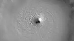
- Hurricane Milton’s Clear, Breathtaking Eye - RAMMB-CIRA Satellite Librarysatlib.cira.colostate.edu Hurricane Milton’s Clear, Breathtaking Eye - RAMMB-CIRA Satellite Library
On October 8, 2024, Hurricane Milton presented a clear, breathtaking eye over the Gulf of Mexico. Milton’s eye wall contained powerful winds of 165 mph (265 km/hr) as a Category 5 storm. More imagery of Hurricane Milton can be found on its event page.
- End of an era: Historic Landsat 7 mission takes final images | U.S. Geological Surveywww.usgs.gov End of an era: Historic Landsat 7 mission takes final images | U.S. Geological Survey
RESTON, Va. — After more than 132,000 trips around the Earth and more than 3.3 million satellite images under its belt, the work of the Landsat 7 satellite is complete, even as the Landsat science mission continues with newer satellites.
- Report: Low Earth Orbit (LEO) Satellite Systems Like Starlink Cause Environmental Harm Regulators Didn’t Prepare Forwww.techdirt.com Report: Low Earth Orbit (LEO) Satellite Systems Like Starlink Cause Environmental Harm Regulators Didn’t Prepare For
Last June scientists warned that low-Earth orbit (LEO) satellites constantly burning up in orbit could release chemicals that could undermine the progress we’ve made repairing the ozone layer. Rese…

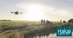
- Rice Farming Gets an AI Upgrade | Hakai Magazinehakaimagazine.com Rice Farming Gets an AI Upgrade | Hakai Magazine
Agricultural drones are transforming rice farming in the Mekong River delta, cutting down the amount of pesticides and fertilizers that wash into the ocean in the process.
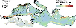
- Mapping Litter In The Oceans From Space With Existing Satelliteshackaday.com Mapping Litter In The Oceans From Space With Existing Satellites
Recently ESA published the results of a proof-of-concept study into monitoring marine litter using existing satellites, with promising results for the Mediterranean study area. For the study, six y…
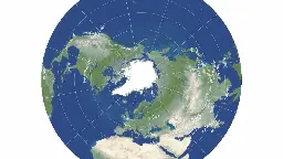
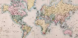
- Princeton astrophysicists re-imagine world map, designing a less distorted, 'radically different' way to see the worldwww.princeton.edu Princeton astrophysicists re-imagine world map, designing a less distorted, 'radically different' way to see the world
Princeton Professors J. Richard Gott and Robert Vanderbei, in collaboration with David Goldberg of Drexel University, have designed a two-sided disk that minimizes the flaws of traditional flat maps.
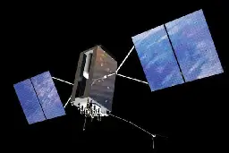
- How Do Satellites Communicate with a GPS System? A Look at the GPS Antenna - Technical Articleswww.allaboutcircuits.com How Do Satellites Communicate with a GPS System? A Look at the GPS Antenna - Technical Articles
Antennas provide the wireless linkage required for any satellite-based system. Here's a look at the many antennas of GPS.
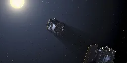
- ESA Satellites to Test Razor-Sharp Formation Flyingspectrum.ieee.org ESA Satellites to Test Razor-Sharp Formation Flying
Proba-3 will make its own solar eclipses—and assess precision orbital tech
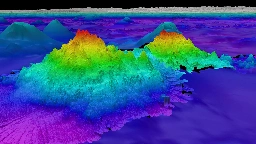
- New Seafloor Map Only 25% Done, with 6 Years to Go - Eoseos.org New Seafloor Map Only 25% Done, with 6 Years to Go - Eos
Beneath the waves, the vast majority of the ocean is unknown. Seabed 2030 is using cutting-edge technologies to fill in the bathymetric blanks and fully map the seafloor.
- What Happens to Google Maps When Tectonic Plates Move?nautil.us What Happens to Google Maps When Tectonic Plates Move?
Earth’s tremors can tweak your GPS coordinates.

- Flightradar24’s new GPS jamming map | Flightradar24 Blogwww.flightradar24.com Flightradar24’s new GPS jamming map | Flightradar24 Blog
Learn how to view areas of GPS jamming affecting aircraft around the world and how GPS jamming affects aviation.
- Germany vs Google: How Street View Won the Privacy Battle in Europe's Most Private Countrypetapixel.com Germany vs Google: How Street View Won the Privacy Battle in Europe's Most Private Country
How Germany lost its spirit of privacy in the face of technological progress.
- Sky lapse in two tone: Using Sentinel-1 radar imagery to make out the shapes of our changing seaborne energy systemblog.datadesk.eco Sky lapse in two tone
Using Sentinel-1 radar imagery to make out the shapes of our changing seaborne energy system
- Why Are There So Many Methane Satellites?heatmap.news Why Are There So Many Methane Satellites?
Over a dozen methane satellites are now circling the Earth — and more are on the way.
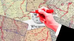
- Rogue Editors Started a Competing Wikipedia That’s Only About Roadsgizmodo.com Rogue Editors Started a Competing Wikipedia That’s Only About Roads
A group of Wikipedia editors wrote 15,000 articles on US roads and highways. But after a fight over the platform's rules, they took a detour.
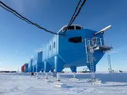
- Antarctica Research Advanced with Lidar | In the Scanblog.lidarnews.com Antarctica Research Advanced with Lidar | In the Scan
LiDAR technology has revolutionized Antarctica research, enabling detailed mapping of ice sheets, topography, and ecosystems
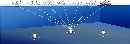
- Unlocking the ocean's secrets: Next-gen tech for precision seafloor mappingphys.org Unlocking the ocean's secrets: Next-gen tech for precision seafloor mapping
The exploration of oceanic resources through seismic methods necessitates precise seafloor geophone positioning. Traditional techniques, however, grapple with issues such as the influence of outliers, suboptimal use of precise observations, and the inefficiency of real-time data processing. These ch...
- Maps shape our lives – showing us not just where we are, but who we aretheconversation.com Maps shape our lives – showing us not just where we are, but who we are
Cartography has become one of the most successful technologies for understanding the world around us. But like the world itself, maps and map-making are constantly evolving.
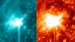
- Powerful twin solar flares erupt from sun as cell phone outages spike across US (video)www.space.com Powerful twin solar flares erupt from sun as cell phone outages spike across US (video)
It remains unclear if there is a connection between the two events.
- Google is making a map of methane leaks for the whole world to seewww.businessinsider.com Google is making a map of methane leaks for the whole world to see
Google is planning to use satellite data, AI, and its computing power to map methane emissions around the globe in a new era of climate accountability.
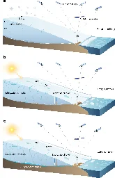
- Solar Eclipses May Initiate Disturbances in Geospace - Eoseos.org Solar Eclipses May Initiate Disturbances in Geospace - Eos
The statistical evidence from 21 years of data suggests that a solar eclipse may trigger a geomagnetic substorm, which is a disturbance in the Earth's magnetosphere and ionosphere.
- New Satellite Will Help NASA Keep PACE with Earth Systems - Eoseos.org New Satellite Will Help NASA Keep PACE with Earth Systems - Eos
Color and light measurements will help scientists better assess how our oceans and atmosphere interact.
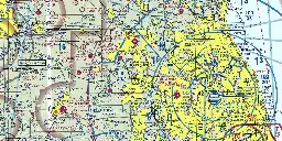
- FAA Aviation Mapswww.beautifulpublicdata.com FAA Aviation Maps
Among all of the visual information published by the U.S. government, there may be no product with a higher information density than the Federal Aviation Administration’s aviation maps.
- Placemark is now open source – web-based geospatial data editorgithub.com GitHub - placemark/placemark: A flexible web-based editor, converter, visualization tool, for geospatial data
A flexible web-based editor, converter, visualization tool, for geospatial data - placemark/placemark

- NASA Worldwind: An open-source high-res satellite globe for web pagesworldwind.arc.nasa.gov Get Started-Web WorldWind/NASA WorldWind
NASA WorldWind Software Development Kits (SDKs) for geo-spatial 3D virtual globe visualization via OpenGL/WebGL on Android, Java and JavaScript/HTML5 platforms.
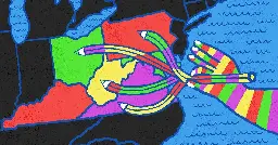
- Only Computers Can Solve This Map-Coloring Problem From the 1800s | Quanta Magazinewww.quantamagazine.org Only Computers Can Solve This Map-Coloring Problem From the 1800s | Quanta Magazine
The four-color problem is simple to explain, but its complex proof continues to be both celebrated and despised.